WET0D
WET0D
News
- 06/11/2013: GLM-FABM-AED workshop at: GLEON15 All attendees welcome!
- 01/10/2013: v1.3.2 : New version of GLM-FABM-AED released
- 01/09/2013: New project modelling effect of water level manipulation on lake resilience
Background
WET0D was initially developed to study long term hydrology-vegetation co-evolution in semi-arid wetlands, but has been applied in other contexts. WET0D is fairly simple, so that the phenomena driving model’s results are easy to understand, generating insights into wetland vegetation behaviour. Yet, the model is complex enough to represent real systems and so to be used as a management tool. For instance, Hanna et al. (2011) applied the model to identify the hydrological threats of two clay-pan semi-arid wetlands and Guerra (2011) used the model to study how climate change trends may affect the water balance in a groundwater dominated wetland.
The model was also used across the climate range of the south-west of Western Australia (SWWA) as a screening tool to select sites for assisted colonization of rare reptiles (Mitchell et al. 2012). An early version of the model also gave preliminarily basis for management policies to be implemented in a salinity-threatened wetland in SWWA (Coletti et al. 2012).The model was implemented in MATLAB (Mathworks Inc.) and is resolved at a daily time step.
Rational
The novel aspect of WET0D’s approach is that it dynamically resolves the partitioning of hydrological environments that generate niches for several different vegetation functional groups. The wetland domain is schematically represented as a linked cell model (Figure 1). Water table level (hS) and lake level (hL) are used to divide the wetland into discrete hydrological cells or “environments” of uniform salinity and carbon concentration as well as water content. Each cell n (n=unsaturated soil, saturated soil and lake, represented by U, S and L, respectively) is treated as a well-mixed pool that exchanges water, carbon and salt with neighbouring cells.
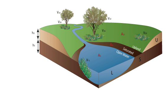
Figure 1: The three storage cells or environments with distinct hydrological function (U, S and L) and their correspondent surface areas (AU, AS and AL).
Inputs and outputs of water, carbon and salt from outside the system, including inflow, outflow, and evaporation from bare soil and plant transpiration are applied to each cell, and calculated as a function of vegetation biomass, water availability and salinity found at each time step in each cell (Figure 2).
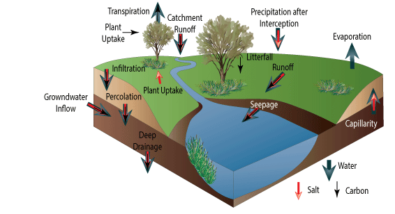
Figure 2: Water, salt and carbon fluxes through the three cells that define the wetland zonation.
Each defined vegetation group most optimally obtains water and increase biomass within areas suited to their water uptake strategies. The amount of water that each vegetation group transpires depends on the hydrological environment and the salinity of the cell in which they are situated at any given time and also on its own characteristics. The approach is therefore a quasi-spatially explicit analysis.
Vegetation success in assimilating carbon is dependent on the spatiotemporal availability of its habitats, which is affected by vegetation itself. As such, the ecohydrological model is unique in predicting the long-term co-evolution between hydrology and vegetation.
For instance, after a long term of climate forcing in dynamic equilibrium, a wetland presents the correspondent vegetation zonation at time t=1 (Figure 3). After a flooding event (at time t=2), vegetation not adapted to waterlogging conditions would be sitting in an unfavourable, saturated environment. Unable to uptake water and carbon, after many interactions (at time t>>2), if the climate does not suffer another shift, the unadapted vegetation will die and the adapted vegetation will flourish along the whole extend of its suitable environment.
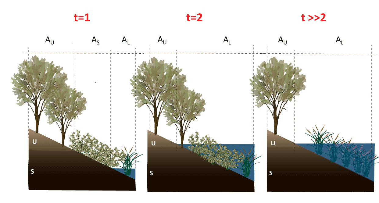
Figure 3: The vegetation-hydrology co-evolution as a response to the long-term inter-relation between water and plants.